
Work completed at The East Group
Grading Implementation & Civil 3D Consulting
Grading plans are some of the most important drawings in a site package, and one of the easiest places for small mistakes to become expensive problems.
I help landscape architecture firms build more reliable grading workflows using Civil 3D, so teams can produce clearer plans, reduce rework, and stop relying on manually drafted contours, copied spot grades, and hand-checked slopes.
Whether your team is using Civil 3D like regular AutoCAD, struggling with inconsistent grading standards, or depending on one power user to make every project work, Deconstruct Terrain helps turn grading into a repeatable system.
Does this sound familiar?
-
Grading plans take longer than they should.
-
Staff are manually drafting contours or copying spot grades between sheets.
-
Civil 3D is installed, but mostly used like standard AutoCAD.
-
Only one person in the office really knows how to grade efficiently.
-
Slopes, spot grades, and contours are difficult to check.
-
Ramps, walks, plazas, walls, and drainage areas create recurring production issues.
-
QA/QC happens too late, after the grading plan is already hard to fix.
-
The civil engineers and surveyors send you Civil3D objects you cannot utilize.
Grading plans should be dynamic, not just linework.
Many landscape architecture firms have Civil 3D, but their grading workflows are still built around static linework, manual edits, and project-by-project workarounds.
That may work on simple sites, but it becomes risky when projects include accessible routes, ramps, plazas, walls, curb transitions, building thresholds, or complex drainage.
A better grading workflow should help your team model intent, check slopes, update labels, coordinate with civil engineers, and produce clearer construction documents without rebuilding the same process from scratch on every project.
Deconstruct Terrain often uses feature line-based grading because it closely matches how landscape architects think about walks, edges, walls, plazas, swales, and other hardscape elements.
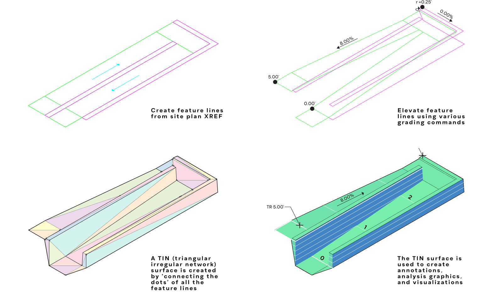
Feature Line Grading Workflow utilized at Deconstruct Terrain
Services
01
Grading Workflow Implementation
Build a repeatable Civil 3D grading process for landscape architecture projects.
This can include:
-
Proposed surface setup
-
Feature line grading workflows
-
Spot grade, slope label, and contour standards
-
Surface cleanup and troubleshooting
-
QA/QC review process
-
Coordination workflows for civil engineers and internal teams
02
CAD Standards & Team Enablement
Create the standards, templates, and training your team needs to use the workflow consistently.
This can include:
-
Civil 3D template and label style setup
-
AutoCAD/Civil 3D layer, xref, block, plotting, and sheet standards
-
Office-specific grading documentation
-
One-on-one or small group training
-
QA/QC checklists
-
Ongoing support for project implementation


Work completed at Bolton & Menk
Work completed at RATIO Design
Who This is For
Built for Landscape Architecture Firms That Want To:
-
Take more control over grading instead of relying entirely on civil engineers
-
Improve production efficiency without hiring a full-time Civil 3D specialist
-
Standardize grading workflows across a small team
-
Reduce redlines and late-stage grading revisions
-
Train staff to use Civil 3D more effectively
-
Build a repeatable system for plazas, walks, ramps, walls, swales, and hardscape grading
Civil 3D Support From Someone Who Understands Landscape Architecture
Most Civil 3D support is built around civil engineering workflows. Deconstruct Terrain focuses on how landscape architects actually grade outdoor spaces: walks, plazas, ramps, terraces, walls, planting areas, drainage transitions, and construction documentation.
The goal is not just to build a template. The goal is to create a grading workflow your team can actually use.